Application Call – Frozen ground Comic
![]()
]]>
read more]]>
*all credits: http://www.inrs.ca/english/actualites/ghg-emissions-canadian-arctic-aquatic-systems-dated-first-time by Gisèle Bolduc*
For the first time, researchers have successfully dated the carbon dioxide (CO2) and methane (CH4) emitted by ponds and lakes on Bylot Island, Nunavut. The research team observed significant variability in age and emission rates of greenhouse gases (GHG) from aquatic systems located in a continuous permafrost zone. The study, whose lead author is Frédéric Bouchard affiliated to the INRS Eau Terre Environnement Research Centre and the Geography Department of Université de Montréal, appeared in the international journal Biogeosciences.
Gas samples taken over the summer showed strikingly different ages and emission rates depending on the size and depth of the water bodies. Carbon-14 dating revealed that gas emitted by shallow ponds was a few centuries old, making it relatively “young”. Certain ponds, covered by cyanobacterial mats, were identified as CO2 sinks and sources of CH4; others, with eroded banks, were significant emitters of both GHG. Compared to ponds, arctic lakes were found to release much older GHG—up to 3,500 years old in the case of CH4—but at a much slower rate, at least in summer.
“This study demonstrates the significant impact of the combined geomorphological, limnological, and hydrological properties of aquatic systems on CO2 and CH4 emissions caused by thawing permafrost,” noted Professor Isabelle Laurion.”
The research team approach enabled an estimation of GHG emissions caused by two distinct processes: diffusion and ebullition. Researchers found that diffusion can be a significant mode of emission, especially from ponds. Until now, ebullition had been considered the predominant mode of CH4 emissions in lake systems.
“This study on the age of GHG emitted in the Canadian Arctic is one of very few using data from lakes outside of Siberia or Alaska. It sheds light on the specific role played by aquatic systems on carbon dynamics associated with thawing permafrost, and their potential impact on future climate change,” stated researcher Frédéric Bouchard
This work sets the scene for further research that must not only measure gas exchange rates, but also account for the age of carbon emitted, since this will impact the systems’ potential positive feedback effect on climate.
About the publication
This research was conducted by Frédéric Bouchard, Isabelle Laurion, and Vilmantas Prėskienis, of the INRS Eau Terre Environnement Research Centre, along with Daniel Fortier of Université de Montréal, Xiaomei Xu of University of California, and Michael J. Whiticar of University of Victoria. The resulting article, “Modern to millennium‐old greenhouse gases emitted from ponds and lakes of the Eastern Canadian Arctic (Bylot Island, Nunavut),” was recently published in the international journal Biogeosciences (DOI: 10.5194/bg-12-7279-2015). Financial support for the research team was provided by ArcticNet, the Natural Sciences and Engineering Research Council of Canada (NSERC), Natural Resources Canada’s Polar Continental Shelf Program, NSERC’s Discovery Frontiers and EnviroNorth programs, and the W. Garfield Weston Foundation.
]]>read more]]>
Abstract :
To measure the impact of water flow on permafrost degradation, several experiments of active layer physical models were conducted in laboratory. Eight wooden cells filled with different quasi-saturated soils were subjected, for the first half, to a thawing by conduction and for the other half to a thawing by convection (water flow). The purpose of this protocol is to develop, with experimental data, tools to quantify the efficiency of thawing by conduction in comparison to thawing by convection.
]]>read more]]>
Abstract
The Beaver Region is located in southwestern Yukon and was not glaciated during the last glacial advance (Late Wisconsinian, 26-11.7Ky BP). The site lies on Middle Wisconsinian to Holocene deposits covering a disintegration moraine; prior cryostratigraphic investigations have shown the presence of ice-rich cryofacies and syngenetic ice wedges down to 10 m below the surface. The objective of this paper is to propose a conceptual model linking the permafrost cryostratigraphy to the post-glacial climate history. 29 boreholes have been analysed in relation to the topography, ecology and pedology. Five cryostratigraphic units have been defined, characterized and related to specific development stages. As results, the contemporary landscape can be defined in two contrasted zones; mesic convex, and humid concave areas. This differentiated geomorphology affects the modern landscape evolution from a geothermal, hydrologic, ecologic, pedogenic and cryogenic perspective.
]]>read more]]>
Figure 1: Main conclusions from the three case-studies
Abstract:
Using examples from three case studies in Yukon communities, we investigate the role of anthropogenic disturbance on permafrost landscapes. Landscape modifications investigated include alternations to surface vegetation for fire protection adjacent to communities, and land clearing to support economic activities like surface mining and agriculture. In most cases, the removal of protective vegetative cover resulted in permafrost degradation, leading to the development of near-surface taliks over decadal-scale time periods. Conversely, light alteration to vegetative cover (e.g., stand thinning for fire protection) does not appear to have altered permafrost presence or distribution. Results have implications for community-scale land use planning in the context of a changing climate.
]]>
read more]]>
Link to the presentation (slideshow)
Figure 1. Mapping and sampling lake bottom on Bylot Island, Nunavut. (a) Satellite image showing the sampled kettle lake within a glacial valley. (b) Bathymetric map generated using a GPS-sonar system. (c) Photo of a 37-cm long sediment core collected from the deepest part of the lake. (d) Portable GPS-sonar system installed on a small zodiac.
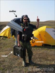
Figure 2. The ‘Zodiac Sherpa’, proudly transporting his lake-bottom imagery tool-kit across permafrost landscapes. Photo: Vilmantas Preskienis (July 2014).
Abstract:
Widespread and diverse in permafrost landscapes, freshwater ecosystems play a crucial role in maintaining the traditional lifestyle of northern communities as habitats for aquatic plants and wildlife, and many are also biogeochemical hotspots that strongly emit greenhouse gases. Limnological and paleolimnological studies are of great importance for understanding the past, present and future dynamics of such aquatic systems. This paper presents a novel, highly integrated lake-bottom imagery strategy for surveying lake-bottom water and sediments prior to sampling. It is user-friendly and easily portable, can be implemented rapidly in the field with directly accessible data, and is much less expensive than regular lake basin surveying techniques. The method integrates GPS-assisted sonar technology, underwater HD photo-video camera, and water depth and temperature sensors. Examples from Canadian High Arctic permafrost landscapes, where the method has been recently applied, are reported and discussed.
]]>read more]]>
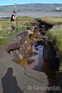 Figure 1: Example of ice-wedge and surrounding permafrost degradation through thermo-erosion. Bylot island, summer of 2013. |
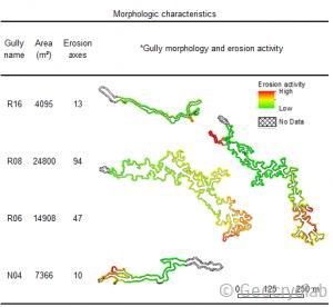 Table 1: Morphologic characteristics of 4 gullies and their erosion activity pattern |
If you want to know more, you can find my presentation and article on Research Gate, here are the links, enjoy!
]]>
]]>
read more]]>
The water flow was 0.5 cm3/h and the temperature was 15°C.
The film was made with using an Infrared camera. While the temperature was not calibrated in this visual representation, temperatures ranges obtained with the IR camera are realistic. The purple and blue tones indicate warm temperatures, while yellow colors indicate warmer temperatures.
The wooden cell represents a physical model of the active layer of permafrost. This protocol allows quantifying the effect of water flow on permafrost degradation.
]]>
read more]]>
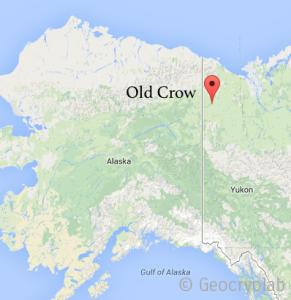
Old Crow, Yukon
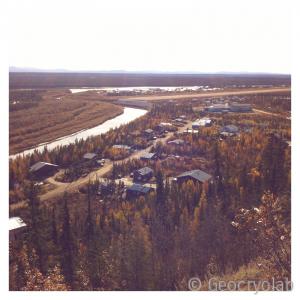
Old Crow, from a nearby hill